Stitched Across the Water: Can the New Saigon River Pedestrian Bridge Actually Bridge Two Cities?
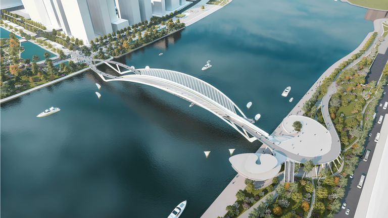
Architectural rendering of the pedestrian bridge across the Saigon River. | Source: Chodai–Takashi Niwa Architects and Chodai Kisojiban Vietnam Consortium
On the morning of October 21, 2026, construction crews locked into place the final steel segments of the main span across the Saigon River, physically stitching together the historic heart of District 1 with the rapidly developing peninsula of Thủ Thiêm.
Measuring 720 metres from bank to bank, the pedestrian and bicycle crossing connects the manicured promenade of Bến Bạch Đằng directly to Thủ Thiêm’s expanding riverside park. Slated for an official opening ahead of the Lunar New Year in early 2027, the bridge has already been hailed as an architectural triumph and a fresh visual icon for Vietnam’s economic engine.
Yet, in a metropolis historically dominated by millions of motorbikes and increasingly choked by private cars, can a single non-motorized crossing fundamentally alter how people move? Ho Chi Minh City has spent the past decade investing heavily in riverfront public realms and isolated recreational trails. However, the true value of civic infrastructure is rarely measured by how attractive it looks on a postcard or how many visitors it draws on a Sunday evening. Its lasting significance depends on whether it operates as an ornamental destination or as a functional, indispensable spine of everyday urban transit.
Close On The Map, Far On The Ground
To understand why the new river crossing matters, one need only look at the everyday friction between neighbouring districts. In geographical terms, the working-class density of Xóm Chiếu, Khánh Hội, and Vĩnh Hội ward sit virtually within sight of the gleaming residential blocks of Sala in Thủ Thiêm. On a map, the distance is modest, a straight-line stretch of water and low-lying land. On the ground, navigating between them without an engine is an arduous logistical exercise.
For a cyclist or a determined walker, the journey has long required a circuitous detour. The Saigon River Tunnel, the most direct subterranean route between District 1 and the peninsula, strictly forbids pedestrians and non-motorized two-wheelers. Travellers on foot or pedal power are pushed toward vehicular crossings such as Ba Son Bridge or the older Thủ Thiêm Bridge to the north. Taking these detours turns what should be a ten-minute crossing into a protracted multi-kilometre journey alongside roaring commuter traffic, steep bridge approach ramps, and exhaust fumes.
This disparity illustrates one of urban planning’s most persistent paradoxes: geographical proximity does not equal functional accessibility. As researchers Cheryl Prendergast and Catherine Earl documented in their 2025 RMIT Vietnam study on walking barriers in the city, ordinary movement across Ho Chi Minh City is systematically compromised by physical fractures. Expressways, wide river channels without active-transit access, and fragmented local streets routinely sever neighbouring communities. Even where physical space exists, sidewalks are frequently colonized by parked motorbikes, street vendors, and uneven paving. The result is a city where even short journeys demand motorized transport simply because the non-motorized alternative feels unsafe, unviable, or physically impassable.
The Terminal Problem: Where Infrastructure Meets the Street
A bridge, no matter how elegant its cable-stayed lines or how generous its timber decking, is only ever as viable as the streets feeding into both ends. The Saigon River pedestrian bridge introduces a dedicated bicycle track alongside its pedestrian walkway. Yet the moment riders and walkers descend its access ramps, they must continue their journeys through the existing street network.
On the western bank, the crossing touches down at Bến Bạch Đằng, a revitalized waterfront park that has quickly become one of the city centre’s most popular evening gathering spots. But behind Bến Bạch Đằng lies Tôn Đức Thắng, a multi-lane riverside boulevard that acts as a formidable concrete barrier between the waterfront and the urban core. While underpasses and surface signal crossings have improved foot access from pedestrianized Nguyễn Huệ and Đồng Khởi, navigating inward on foot remains an intimidating task for many, while cyclists face immediate, unbuffered conflicts with fast-moving traffic.
Across the water in Thủ Thiêm, the dynamic reverses. Here, wide expanses of open green space and the newly constructed riverside park offer ample room, but onward connectivity remains patchy. The city has made notable progress, such as introducing a nearly 5.8-kilometre dedicated cycling corridor along Mai Chí Thọ. Yet linking the bridge’s eastern landing to that corridor requires navigating unfinished construction parcels, broad arterial crossings, and junctions built with high-speed motorized throughput in mind. If a cyclist crossing from Bến Bạch Đằng cannot yet pedal smoothly and safely into Sala, An Khánh, or local commercial centres without abruptly being forced into mixed traffic, the bridge risks becoming a dead-end promenade rather than a functional piece of transit infrastructure.
The Difference Between Leisure And Utility
The deeper challenge facing Ho Chi Minh City’s active-mobility ambitions is cultural and structural: connecting spaces designed for leisure with routes that serve everyday transportation needs.
Waterfront promenades, landscaped piers, and scenic boardwalks are essential civic assets that enhance quality of life. But walkability is not achieved simply by laying stone pavers along a river. True walkability is functional. It requires that residential quarters, markets, workplaces, schools, and medical clinics be linked by direct, continuous, and shaded paths that make leaving the motorbike at home a sensible choice rather than a heroic physical feat.
Thủ Thiêm offers a clear study in this tension. Based originally on a master plan by Sasaki, the new urban area was conceived with modern sustainability ideals: public waterfront access, integrated canals, and transit-oriented development. In reality, much of the peninsula’s initial development has favoured monumental block sizes, deep building setbacks, and car-oriented scaling that dwarf the human pedestrian. Wide streets designed for high capacity can make a 400-metre walk in midday tropical heat feel punishing.
Climate cannot be engineered away, but its effects can be dramatically mitigated. In southern Vietnam’s tropical conditions, where temperatures regularly exceed 34 degrees Celsius before giving way to torrential monsoon downpours, active mobility may require shade canopies, continuous tree cover, rain-sheltered arcades, and street-level retail that activates the journey. Without these practical considerations, the new pedestrian bridge will thrive during the cool breezes of twilight as a gathering spot for tourists and evening strolls, while sitting largely deserted during the working hours when the city’s transport network is under the greatest strain.
Moving From Landmarks To Networks
As municipal authorities prepare for the bridge’s early 2027 opening, the conversation surrounding the project must shift from engineering pride to systemic integration. Ho Chi Minh City has set an ambitious policy target for the 2026–2030 period: ensuring that the vast majority of urban residents have access to reliable public transport within a 300 to 500-metre walk.
Achieving that benchmark requires acknowledging that walking and cycling are the indispensable first and last miles of any effective public transit ecosystem. The new bridge sits within reasonable reach of key transit nodes, including the water bus terminal at Bến Bạch Đằng and the underground stations of Metro Line 1, such as Ba Son and the central Bến Thành interchange. Its role in cross-river mobility could be further strengthened through measures such as bike-share hubs at both landings, clear wayfinding, continuous traffic-calmed feeder routes, and seamless step-free access. Together, these elements could help make cross-river commuting more practical for workers traveling between District 1 and Thủ Đức City.
Evaluating the bridge’s ultimate success should rely on the true metrics such as: the number of daily bicycle commutes recorded on regular Tuesday mornings, the safety records of the junctions at either landing, and whether local residents begin to view crossing the Saigon River on foot as an ordinary part of daily life.
The new bridge marks an exciting step in how Ho Chi Minh City connects across the Saigon River. As anticipation builds ahead of its opening, it also offers a chance to see how the city’s walking and cycling networks might grow around it. A bridge can open in a day, but a more connected city takes shape step by step, with each improvement bringing everyday journeys a little closer together.